Soil Moisture Mapping in Highly Heterogeneous Agricultural Landscapes

Soil moisture (SM) controls the exchange of water and energy at the ground–atmosphere interface. Robust ground‐based SM products with a spatial resolution of hundreds of meters and a spatial coverage of tens of kilometers are needed to improve catchment‐scale hydrological models used for water resource management, drought monitoring, and warning systems for wildfires and floods.
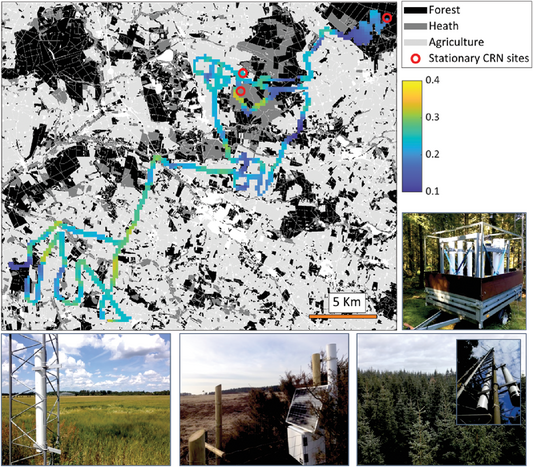
Researchers introduced a novel approach for mobile cosmic‐ray neutron (CRN) systems, which measure neutrons produced by incoming cosmic radiation from space interacting with hydrogen atoms in soil moisture, to map SM at a spatial scale of tens of kilometers in heterogeneous landscapes. They combined neutron datasets of two energy ranges with theoretical developments to create a simplified process that identifies different land cover types using the neutron data alone without the need for numerous soil samples collected along the survey route.
The team tested the approach in a catchment in western Denmark and found it provides more realistic SM values across the three dominant land cover types compared with the standard approach for CRN SM mapping. The mean SM values were both more consistent with measurements from a capacitance sensor network and with local knowledge.
Adapted from
Andreasen, M., Kragh, S. J., Meyer, R., Jensen, K. H., & Looms, M. C. (2023). Mapping spatiotemporal soil moisture in highly heterogeneous agricultural landscapes using mobile dual‐spectra cosmic‐ray neutron sensing. Vadose Zone Journal, 22, e20287. https://doi.org/10.1002/vzj2.20287
Text © . The authors. CC BY-NC-ND 4.0. Except where otherwise noted, images are subject to copyright. Any reuse without express permission from the copyright owner is prohibited.


